
Miami’s October king tide ran 1.81 feet above prediction at its measured peak
An original analysis of NOAA’s Virginia Key readings shows how actual water levels exceeded tide predictions during Miami’s late-October 2026 flooding.
The late-October flooding was more than a high tide arriving on schedule. At NOAA’s Virginia Key gauge, the highest water level measured during October 22–31 reached 1.81 feet above the tide prediction for that same moment, according to Miami Finder’s analysis of the agency’s preliminary six-minute data.
The peak arrived at 10:18 a.m. EDT on October 27, 2026. The gauge measured 2.54 feet above its mean higher high water reference; the prediction was 0.73 feet above that reference. In the source units, those figures are 0.775 meters measured, 0.222 meters predicted and a difference of 0.553 meters. These are water levels at one coastal gauge—not depths on Miami streets. NOAA Virginia Key water-level records
For someone deciding whether to drive, park or walk near Biscayne Bay, the distinction matters: a tide calendar identifies the astronomical cycle, but it does not promise the height of the water outside a hotel or garage.
What the ten-day record shows
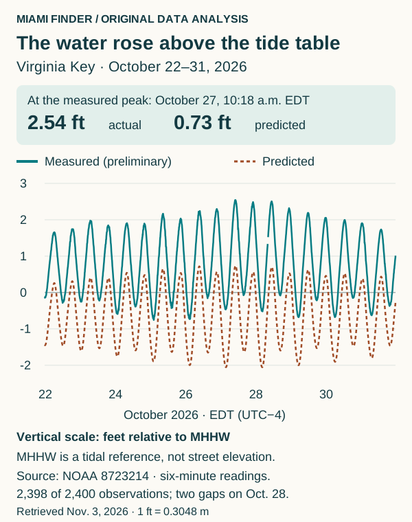
Original analysis of NOAA station 8723214. Both lines use the same datum and timestamps. The two missing observations on October 28 are left as a gap.
We matched every scheduled six-minute observation with the prediction for the same timestamp, covering ten complete Miami calendar days. Of 2,400 expected pairs, 2,398 had a usable observation. All measured values were marked preliminary when retrieved on November 3.
The water ran above prediction throughout the available record. The average difference was 1.44 feet (0.439 meters). That is an average of matched readings, not the average daily high and not a measured depth of flooding.
The highest observed water and the largest prediction gap did not occur at the same time. The water-level peak was on October 27 in the morning. The biggest gap—1.92 feet (0.586 meters)—came at 10:30 p.m. that night, when a lower predicted tide still coincided with high measured water.
Here is a closer look at the central days. Each prediction below is for the time of that day’s measured maximum, rather than the day’s separate predicted maximum. Heights and differences are in meters; 1 foot equals 0.3048 meters.
| Date | Measured maximum time, EDT | Measured, m MHHW | Prediction at that time, m MHHW | Difference, m |
|---|---|---|---|---|
| October 25 | 8:54 a.m. | 0.660 | 0.198 | 0.462 |
| October 26 | 9:42 p.m. | 0.700 | 0.172 | 0.528 |
| October 27 | 10:18 a.m. | 0.775 | 0.222 | 0.553 |
| October 28 | 11:12 a.m. | 0.764 | 0.213 | 0.551 |
| October 29 | 12:06 p.m. | 0.668 | 0.190 | 0.478 |
Download all six-minute readings and their source URLs, or use the ten-day daily summary.
Why flooding does not require a hurricane landfall
High coastal water can reach low land even without a hurricane moving through the city. Miami Beach’s explanation is direct: when king tides rise above adjacent land, flooding can occur, including on days without rain. That describes a mechanism, not a claim that every flooded street in October had the same cause. City of Miami Beach king-tide guidance
The timing was anticipated. In its August 4 forecast, the South Florida Water Management District identified October 27 as the East Coast’s annual maximum predicted peak and listed October 22–November 12 as a broader elevated-tide period. Its forecast also explains that winds and ocean currents can move water levels above or below tide predictions. SFWMD’s 2026 season forecast
Street flooding had already appeared near Northeast 79th Street in Miami by October 23, according to WSVN’s dated report. That local reporting establishes an impact; our gauge analysis adds a separate measurement record. WSVN’s October 23 report
For the late-October event, National Weather Service meteorologist Chris Fisher told the Associated Press that high pressure to the north and low pressure over the Caribbean were increasing swells. That is the forecaster’s explanation, not a result inferred from our subtraction. AP’s October 28 report
NOAA says its tide predictions describe astronomical tides and do not predict the effects of short-term weather such as wind, rain and runoff. The observed-minus-predicted difference therefore shows what the tide table did not capture; it does not isolate one cause, quantify climate change’s contribution, or prove a drainage-system failure. NOAA’s explanation of prediction accuracy
How to use this before the next tide window
The City of Miami lists November 6–9 and November 23–26 as the remaining 2026 king-tide windows. Treat those as dates to check conditions, not a forecast that October’s water levels will repeat. Avoid low parking areas, do not enter floodwater, and follow current local notices before traveling. City of Miami’s schedule and precautions
For timing and route planning, our remaining 2026 king-tide guide provides the broader calendar. Closer to your trip, check the enhanced tidal outlook linked by Miami Beach, which includes conditions beyond the astronomical tide.
What the measurements can—and cannot—tell you
MHHW means mean higher high water: the average higher high tide of each tidal day over a reference period. Virginia Key’s metadata identifies its datum epoch as 1983–2001. It is not street elevation, a flood threshold, or a synonym for mean sea level. NOAA datum definitions · Virginia Key datum metadata
We requested both NOAA products in meters relative to MHHW and UTC, then converted timestamps to Miami time. The entire study window was EDT, UTC−4. Missing observations at 8:36 and 8:42 a.m. EDT on October 28 were excluded without interpolation. Six-minute samples may miss a brief higher level between readings, and preliminary data may change after NOAA verification.
This comparison establishes a large departure from predicted tides at Virginia Key. It does not measure flooding at individual addresses or establish an all-time record.