
Palm Beach Learjet crash: ATC audio, transcript and final flight data
What is confirmed about the November 1 Palm Beach Learjet crash, with the complete published ATC excerpt, its community transcript and a flight-data chart.
Updated November 2, 2026. The investigation is ongoing.
Nine people died when a Learjet 60 crashed in Palm Beach County on Sunday, November 1. The aircraft, registered N722BD, was flying from Austin, Texas, to North Eleuthera in the Bahamas. The crash happened in the Cresthaven/Greenacres area, north of Miami—not at Miami International Airport. The FAA’s incident statement places the accident at about 12:50 p.m. local time; the Associated Press confirmed the nine deaths on November 2.
This page brings together three different records: a publicly available air-traffic-control audio excerpt, a community transcript of that excerpt, and an original visualization of received flight-tracking data. They help readers follow the available evidence. None establishes the cause of the crash.
Listen: the complete published audio excerpt
Content note: The recording contains distress, shouting and profanity. Playback is optional and does not start automatically.
This is the entire approximately 1 minute 56 second excerpt published on Wikimedia Commons. It is edited, and it is not a verified uninterrupted recording of the aircraft’s final minutes. Audio time below is elapsed playback time, not a clock synchronized with the flight-data chart. The number of minutes of real time represented by the edited recording has not been established here.
The crew reports turbulence and icing, asks for a climb, and later declares an emergency while reporting a rapid descent. The controller acknowledges the calls and continues trying to contact the aircraft. The reference to “Miami” at the end is a radio identification; it should not be read as the crash location.
Audio source and file history. Commons marks the recording as public domain. We have preserved the excerpt in full; the MP3 is a format conversion for browser playback.
Longer recording from Método Crítico: the publisher presents a 2 minute 26 second version as uncut, covering 12:47:21–12:49:47 p.m. EST, with a synchronized flight visualization and credit to LiveATC. We could not independently check it against the original LiveATC archive. Its duration and presentation differ from the excerpt transcribed below. Read the publisher’s accompanying account.
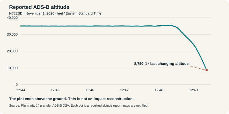
What the flight data shows

The chart uses Flightradar24’s published granular ADS-B data, starting at 12:44 p.m. Eastern Standard Time. The points remain close to 35,000 feet before the descent visible after 12:48. The final new altitude value plotted is 8,750 feet at 12:49:22.955 p.m. EST, rounded to 12:49:23 when expressed to the nearest second. Three subsequent rows repeat that same altitude; they are omitted rather than presented as further changing altitude measurements.
The plot contains 648 altitude reports. It uses received values without adding points through missing reception, extending the descent to the ground, or aligning individual radio calls to assumed flight positions. Barometric altitude is not height above the local terrain. Flight-tracking data can contain limitations and anomalies; the curve alone cannot explain why the aircraft descended.
Download Flightradar24’s original CSV or read its flight-tracking account.
Full transcript of the published excerpt
This is a community transcription, not an official FAA or NTSB transcript. It includes all captions in the published excerpt, including controller transmissions and crew calls. “[Inaudible]” and other uncertainty markers are retained. Speaker labels distinguish the apparent crew and controller; they do not identify individual pilots. The final spoken name is marked “[name unclear]” rather than asserting the community transcription’s interpretation.
Timestamps refer only to playback in the excerpt above. The audio is the source to consult when wording is uncertain.
00:00–00:06 · Crew
722BD, 350, moderate turbulence, plus or minus...
00:06–00:10 · Crew
okay, now 700 feet, 600 feet...
00:10–00:13 · Controller
November [inaudible] roger. Say outside air temperature?
00:13–00:18 · Crew
-47°C. We're managing the ice,
00:18–00:20 · Crew
but it is moderate turbulence. We're direct Freeport.
00:20–00:24 · Controller
Okay, N722BD, roger, let me know if you need anything else,
00:24–00:26 · Controller
I'm just working you into my airspace right now.
00:26–00:30 · Crew
Thank you. If you have any better ride, let us know. 2BD.
00:30–00:34 · Controller
N2BD, the ride should improve in my airspace.
00:34–00:37 · Controller
You're kind of far outside of it right now, you can expect a better ride ahead.
00:38–00:42 · Crew
Roger, 2BD. Now we're picking up precipitation.
00:42–00:45 · Crew
We need to climb 370 if able. 2BD.
00:46–00:49 · Controller
N722BD, roger. Climb and maintain flight level 370,
00:49–00:52 · Controller
no further right than your present heading for traffic.
00:52–00:54 · Crew
Climb 370. 2BD.
00:54–00:58 · Crew
722BD, we're descending 8,000. Mayday, mayday.
00:58–00:59 · Crew
We're descending 10,000 feet per minute.
01:00–01:03 · Controller
N722BD, roger.
01:03–01:06 · Crew
Declaring an emergency, 722BD.
01:06–01:10 · Crew
We are in an overspeed condition. Descending 20,000 feet per minute.
01:10–01:13 · Controller
N722BD, roger. Altitude your discretion,
01:13–01:15 · Controller
let me know what you need.
01:15–01:20 · Crew
We're going to crash into the ground. 722BD.
01:20–01:21 · Crew
[scream]
01:22–01:25 · Controller
N2BD, I'm here with you. Talk to me.
01:25–01:32 · Crew
We are descending 22,000 feet, and we are banking 60 degrees. [inaudible]
01:35–01:39 · Controller
N2BD, roger. I'm here with you, [inaudible]
01:39–01:43 · Crew
[scream] [inaudible] Look outside, [name unclear]. Look outside.
01:44–01:46 · Crew
Holy fuck [bleep], we're out of time! [inaudible]
01:46–01:49 · Controller
N2BD.
01:49–01:51 · Controller
N2BD, how do you hear?
01:53–01:55 · Controller
N2BD, Miami.
Transcript credit: Adapted from Wikimedia Commons contributors’ timed text, revision 1295347587, licensed CC BY-SA 4.0. Changes: speaker labels, readable timestamp formatting, and “[name unclear]” replacing the uncertain name. This adapted transcript is available under the same license. The audio’s public-domain status is separate from the transcript’s license.
What investigators have confirmed
The NTSB investigation record, ERA27MA026, lists a Learjet 60 operated by Aurora Aviation doing business as Upper Jet. The NTSB identifies the location as Lake Worth Beach, Florida, and the investigation as ongoing.
Reports of icing, turbulence, an overspeed condition or a particular descent rate in radio calls describe what the crew said at that moment. They are not a finding of probable cause. That distinction matters while investigators examine the aircraft, weather, recordings and other evidence. This page does not assign responsibility or infer a cause from the excerpt or the plotted data.
What South Florida readers should know
This was a Palm Beach County accident, not an accident at a Miami airport. For people traveling north from Miami, the relevant immediate disruption was local road access near the crash scene. Local 10 reported on November 1 that Military Trail was closed between Cresthaven Boulevard and 10th Avenue North.
That is a dated closure report, not confirmation that the road remains closed on November 2. Check current local traffic and official public-safety updates before traveling near the scene. The FAA and NTSB pages linked above are the primary sources for changes to the official accident record.