
How to Explore Miami Beach’s Oceanfront Path from South Pointe North
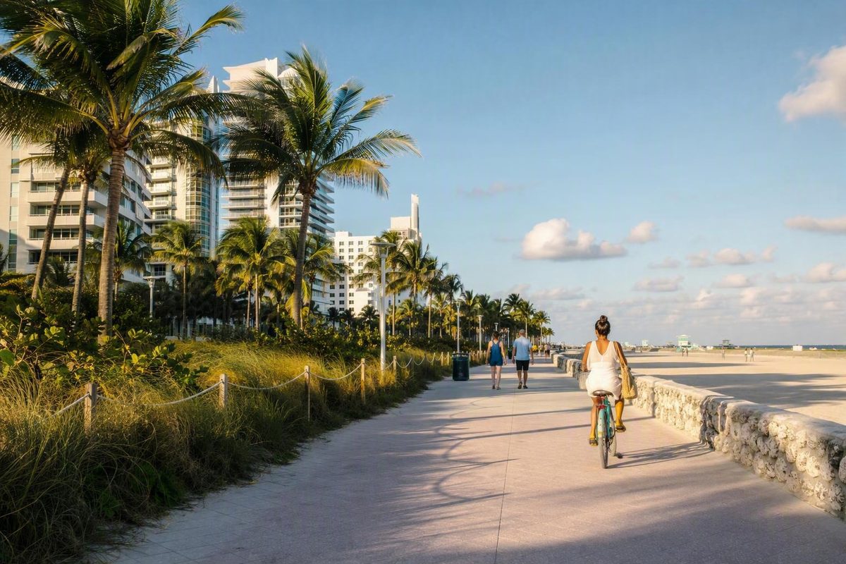
Choose Lummus Park for a compact stroll, or start at South Pointe Park and walk toward Lincoln Road or 23rd Street for the main landmarks.
The boardwalk in South Beach is the southern portion of Miami Beach’s modern Beachwalk: a paved oceanfront promenade beginning at South Pointe Park and continuing north through South Beach, Mid-Beach, and North Beach.
Planning note: Route descriptions below use municipal and tourism sources for the path’s endpoints, surface, hours, and accessibility. Parking, transit, closures, facilities, weather, and device rules can change, so verify details with the relevant operator or the City of Miami Beach before departure.
Quick answer: where is the boardwalk in South Beach?
“South Beach Boardwalk,” “Miami Beach Boardwalk,” and “Beachwalk” are often used interchangeably. Beachwalk is the clearest current name because it is the name the City of Miami Beach uses for the modern route.
For the full route, use the city’s definition: the Beachwalk runs from South Pointe Park to 87th Street, covers nine miles, and forms part of the Atlantic Greenway Network. It also connects with pathways continuing north toward Surfside and Bal Harbour, so the promenade may not feel as though it ends at Miami Beach’s municipal boundary. See the City of Miami Beach’s Beachwalk description.
For a South Beach-focused outing, concentrate on the section running north from South Pointe Park past:
- the South of Fifth area;
- the entrance around 5th Street and Ocean Drive;
- Lummus Park;
- Ocean Drive and the adjacent Art Deco District;
- the Art Deco Welcome Center near 10th Street;
- Lincoln Road;
- the landscaped and hotel-lined stretch approaching 23rd Street.
The route continues into Mid-Beach beyond 23rd Street. That street is a useful boundary for a South Beach highlights walk, not the northern end of the full Beachwalk.
Three useful route definitions
South Beach highlights section: South Pointe Park to approximately 23rd Street, passing Lummus Park, Ocean Drive, the Art Deco District, and Lincoln Road.
Wider Miami Beach Beachwalk: The city-defined route from South Pointe Park to 87th Street.
Connected paths farther north: Additional pathways continue toward Surfside and Bal Harbour.
Why do some guides say seven miles while the city says nine?
The City of Miami Beach describes the South Pointe Park-to-87th Street route as nine miles. Miami’s official tourism guide describes a seven-mile route from South Pointe Park to North Beach Oceanside Park. The Miami and Miami Beach tourism guide explains its seven-mile route definition.
For practical planning, choose landmarks before thinking about mileage. “South Pointe Park to Lincoln Road” is more useful than deciding to walk “the boardwalk” because it establishes the section you want to experience and gives you a recognizable place to stop.
Older guides may describe a shorter route ending around 46th Street. Those accounts generally refer to a partial South Beach-to-Mid-Beach segment, not the completed route through North Beach.
Why it is called a boardwalk even though it is paved
Despite the familiar nickname, today’s continuous Miami Beach Beachwalk is not a traditional wooden boardwalk. It is a flat, paved promenade.
The name reflects the route’s history. A wooden boardwalk formerly ran approximately between 23rd and 45th streets. That section was replaced with a paver path, and the present route was completed in June 2022, creating a continuous paved connection north to the Surfside border near 87th Street. A current visitor guide summarizes the former wooden section and June 2022 completion.
The modern Beachwalk is described as a wide, on-grade path made with unified pavers. Its character is closer to an oceanfront greenway than an elevated timber walkway: beach and dunes lie on one side, while parks, hotels, streets, and neighborhood entrances appear on the other.
This history explains why older photographs and articles can be confusing. A 2016 account, for example, described both wooden and paved sections and listed activity restrictions then in effect. That material is useful as a historical snapshot, but it does not establish the present surface or current rules.
For current trip planning, expect a paved promenade. Do not rely on old photographs of wooden decking, pre-completion maps, or historical restrictions unless a current official notice confirms that they still apply.
A south-to-north guide to the South Beach section
The easiest way to navigate the Beachwalk through South Beach is by parks and cross streets. You do not need to calculate mileage or commit to the entire route. Choose two recognizable anchors, follow the oceanfront path, and turn around when the outing has met your needs.
The central street references below align with a documented South Beach walking route beginning at 5th Street, passing the Art Deco Welcome Center near 10th Street, and reaching approximately 14th Street before returning through the neighborhood. See the South Beach route description.
| Anchor | Approximate location | What it helps you find | Practical turnaround? |
|---|---|---|---|
| South Pointe Park | Southern tip of Miami Beach | Waterfront paths, park space, playground, and pier area | Yes |
| 5th Street and Ocean Drive | Around 5th Street | Southern entrance to the central Ocean Drive and Lummus Park stretch | Yes |
| Art Deco Welcome Center | Around 10th Street | Visitor orientation and the central Art Deco area | Yes |
| North end of Lummus Park | Around 14th Street | End of the compact central-beach section | Yes |
| Lincoln Road | Around 16th Street | Westbound connection toward the pedestrian mall | Yes |
| 23rd Street | Northern edge of a South Beach-focused outing | Transition toward Mid-Beach | Yes, or continue north |
| Indian Beach Park | Around 46th Street | Mid-Beach access anchor | Yes |
| North Beach Oceanside Park | Approximately 79th–87th streets | Northern portion of the full Beachwalk | Yes |
South Pointe Park
South Pointe Park is the southern anchor of the Beachwalk. Beginning here gives the outing a definite starting point and lets you combine the oceanfront promenade with the park’s waterfront walkways, playground, pier area, and views toward Government Cut. Official state tourism coverage also identifies South Pointe Park as a South Beach destination with walking paths, a playground, and ocean and city views. See the South Beach destination overview.
This starting point works well if you want more than a straight beachfront walk. Explore the southern waterfront first, then follow the Beachwalk north toward central South Beach. The park also makes a natural turnaround for visitors approaching from Lummus Park.
The tradeoff is that starting at Miami Beach’s southern tip adds ground before you reach the familiar Ocean Drive scenery. If your priority is the Art Deco area rather than South Pointe Park, entering around 5th or 10th Street may be more efficient.
5th Street and Ocean Drive
The area around 5th Street and Ocean Drive is a practical gateway to the central South Beach section. From here, head north with the beach beside you and Lummus Park between much of the waterfront route and Ocean Drive.
This entrance suits visitors staying in central South Beach, travelers arriving by transit or rideshare, and families wanting a recognizable meeting point without first going to South Pointe Park.
It is also a useful starting point for a loop-style outing. Walk north on or beside the Beachwalk, then return through the Ocean Drive area. The two legs offer different experiences: the Beachwalk provides the oceanfront setting, while Ocean Drive provides the concentrated architectural streetscape.
Lummus Park and Ocean Drive
Lummus Park borders the Beachwalk from approximately 5th to 14th Street and runs parallel to Ocean Drive. This compact section combines beach access, park scenery, and proximity to familiar South Beach landmarks without requiring a long outing.
The Art Deco Welcome Center near 10th Street is a useful orientation point. From there, you can continue along the waterfront, cross toward Ocean Drive and the architecture, or turn back.
The Beachwalk itself is not a continuous Art Deco street tour. Many notable buildings stand along Ocean Drive, separated from the oceanfront path by parkland, vegetation, beach facilities, and pedestrian areas. You may see parts of the district from the waterfront, but closer architectural sightseeing requires leaving the Beachwalk.
That distinction matters when traveling with a stroller, wheelchair, bicycle, or group. Remaining on the Beachwalk preserves a more continuous paved route. Moving toward Ocean Drive introduces street crossings, denser pedestrian activity, and sightseeing stops.
Lincoln Road
Farther north, Lincoln Road reaches the Beachwalk and offers an east–west connection toward its pedestrian mall.
Lincoln Road works well as a turnaround because it changes the nature of the outing. You can make the waterfront path the main outdoor activity, then move inland for a meal, shopping, or a break from the exposed beachfront environment.
It is also a practical entry point for visitors staying nearby. There is little benefit in traveling south merely to begin at South Pointe Park if the section you want to explore is closer to your accommodation.
From approximately 14th to 23rd Street
North of the central Lummus Park section, the surroundings change gradually. The path passes landscaped areas and oceanfront hotels as it approaches 23rd Street.
This stretch suits visitors who want to extend a central South Beach walk without immediately committing to a much longer Mid-Beach outing. It can also provide runners and conventional cyclists with a more linear continuation after the busy Ocean Drive-adjacent section.
At approximately 23rd Street, decide whether you have completed your South Beach highlights walk or want to continue. Going north leads into Mid-Beach and the area historically associated with the former wooden boardwalk.
Choose a short stroll, a South Beach highlights walk, or a longer outing
There is no single correct amount of the Beachwalk to cover. The best itinerary depends on the weather, your starting point, your group’s mobility and attention span, and whether the promenade is the day’s main activity or a connection between other stops.
Avoid planning around a guaranteed completion time. Crowds, photographs, beach entrances, rest breaks, navigation, and weather can make two outings over the same section take very different amounts of time.
Short option: Lummus Park and the central South Beach waterfront
Use the section from approximately 5th to 14th Street for a compact introduction.
This option provides:
- easy access to the beach environment;
- proximity to Ocean Drive;
- Lummus Park scenery;
- the Art Deco Welcome Center near 10th Street;
- frequent opportunities to turn back or cross inland.
Enter at the point closest to your hotel, transit route, or parking location. Walk north or south until you have seen enough, then return along the same path or use Ocean Drive for a contrasting urban leg.
This is the most adaptable choice for families, first-time visitors, people limiting heat exposure, and anyone fitting the Beachwalk into a broader South Beach day.
Medium option: South Pointe Park through the main South Beach landmarks
Begin at South Pointe Park and continue north through the 5th Street entrance area and Lummus Park. Choose Lincoln Road or approximately 23rd Street as your turnaround.
This framework brings together the principal South Beach waterfront anchors:
- South Pointe Park and the southern waterfront;
- the approach to 5th Street;
- Lummus Park and Ocean Drive proximity;
- the Art Deco Welcome Center area;
- Lincoln Road;
- the landscaped stretch toward 23rd Street.
Choose Lincoln Road if you want to connect the walk with an inland break. Continue toward 23rd Street if the promenade itself is the priority and conditions remain comfortable.
Plan the return leg before starting. You can retrace the waterfront, move inland, use transit, or arrange a rideshare. Do not assume everyone in a group will want to double the outward walking distance.
Long option: continue through Mid-Beach and North Beach
For a longer outing, continue north beyond 23rd Street. Indian Beach Park near 46th Street is a useful Mid-Beach anchor. Farther north, North Beach Oceanside Park and 87th Street help define the northern portion of the full Miami Beach route.
Some older descriptions call the 5th-to-46th-Street section an approximately four-mile boardwalk. That is a valid partial outing, but it is not the full completed Beachwalk. The 2022 boardwalk map contains both references to the newer northern extension and older 46th Street access information, which is why landmark-based planning is more dependable than relying on one isolated mileage figure.
A long outing is often easier as a one-way trip with transportation arranged at the far end. Before passing your preferred turnaround, check transit or rideshare access, bicycle-return arrangements, and whether everyone in the group remains comfortable continuing.
If you estimate duration, calculate it from your normal walking or cycling pace, then add time for:
- crowded sections;
- photographs;
- water and rest stops;
- beach access;
- navigation;
- waiting for other group members;
- weather-related pauses.
For a car-free visit, make the Beachwalk the principal outdoor activity for a Miami Beach half-day rather than repeatedly crossing the city between unrelated attractions. Miami Finder’s guide to exploring Miami without renting a car recommends grouping activities by neighborhood and reserving transit or rideshare for longer connections.
Entrances, parking, trolley access, and car-free planning
You do not have to begin at South Pointe Park. Enter near the section you want to experience and build the outing around a convenient return plan.
Useful access anchors include:
- South Pointe Park for the southern waterfront and a complete South Beach progression;
- 5th Street and Ocean Drive for central access from the south;
- Lummus Park for a compact beach-and-Ocean Drive outing;
- Lincoln Road for a waterfront walk connected to an inland pedestrian area;
- Indian Beach Park for Mid-Beach;
- North Beach Oceanside Park for the northern portion of the city route.
Parking near central South Beach
Two municipal garages reported for central South Beach access are:
- 210 7th Street
- 1301 Collins Avenue
These addresses come from a local access map updated in 2022. The same source identifies trolley corridors along Collins Avenue, Washington Avenue, and Alton Road, but its parking and transportation details should not be treated as live availability. Consult the boardwalk access and parking map, then verify current rates, hours, restrictions, closures, and capacity through official Miami Beach channels.
The City of Miami Beach reports street and surface-lot parking near the Beachwalk, but that does not guarantee a space beside a particular entrance. Events, closures, time limits, and demand can affect central South Beach parking, so identify an alternative garage or entrance before leaving.
Choose parking according to the section you intend to explore. For a Lummus Park stroll, central access avoids an unnecessary approach from the southern end. For an outing beginning at South Pointe Park, consider where you want to finish so the return to the vehicle does not become an unplanned extension.
Trolley, bus, rideshare, walking, and bike share
Miami Beach trolley corridors along Collins Avenue, Washington Avenue, and Alton Road may provide car-free connections to areas near the Beachwalk. Check the current city route information rather than relying on an older frequency or assuming a trolley stops directly beside your chosen entrance.
Public buses can also serve Miami Beach. Rideshare may be useful for a one-way itinerary or when weather or fatigue changes the plan. If you are staying in South Beach, walking from your accommodation may be simpler than using a vehicle.
Confirm both the pickup and return locations before depending on a rental, and distinguish a conventional bicycle from an e-bike when checking path rules.
What to check on the day
Before departure, verify:
- parking prices, restrictions, and operating hours;
- garage and surface-lot status;
- current trolley and bus routes;
- temporary path or beach-access closures;
- special events affecting Ocean Drive or nearby streets;
- bike-share bicycle and dock availability;
- live weather conditions;
- rules for the bicycle or device you intend to use.
A same-day check is particularly important if your plan depends on a precise entrance, accessible facility, return vehicle, or available bicycle dock.
Accessibility, restrooms, fountains, and other facilities
The Beachwalk is described as a wide, paved, on-grade, ADA-accessible route that can accommodate wheelchair users and people pushing strollers. A commercial visitor guide likewise describes the promenade as flat, paved, and shared by pedestrians, cyclists, wheelchair users, and people with strollers. See its Beachwalk accessibility and conditions overview.
That description applies to the promenade. It does not establish that every route from the street, beach entrance, restroom, dune crossing, sandy area, or shoreline access point is wheelchair-accessible. Promenade access and beach access are separate planning questions.
Restrooms, water fountains, playgrounds, and other amenities are available at selected beach entrances and adjacent parks, not continuously on every block. Tripadvisor’s visitor overview also reports water fountains along the route, although facility locations and operating status should be checked when a specific stop is essential. See the Miami Beach Boardwalk visitor overview.
Useful landmarks to investigate when planning facility stops include:
- South Pointe Park;
- Lummus Park and the Art Deco Welcome Center area;
- Indian Beach Park;
- North Beach Oceanside Park.
These are planning anchors, not a complete facility inventory. A park’s general amenities also do not confirm that every individual feature meets a traveler’s accessibility requirements.
For an outing with specific mobility needs:
- Choose the exact section first.
- Identify the intended entrance and exit.
- Confirm the surface between transportation and the promenade.
- Check current restroom and accessible-facility information.
- Plan a shorter fallback route.
- Carry water rather than relying entirely on the next fountain.
Do not assume a named entrance currently provides beach wheelchairs, access mats, or an accessible restroom unless Miami Beach confirms it. The paved promenade can still provide an oceanfront experience when crossing the sand is not part of the plan.
Crowding also affects practical accessibility. A path may be physically accessible while becoming less comfortable when groups stop across it, bicycles pass closely, or sand accumulates near an entrance. A flexible turnaround and less crowded arrival time may make the outing easier.
Walking, running, cycling, and shared-path rules
The official city description supports walking, jogging, and conventional cycling on the Beachwalk. Tourism coverage also portrays the paved route as usable by skaters, wheelchair users, and people with strollers, but that description should not be treated as a complete municipal rulebook for every wheeled device.
Conventional bicycles versus motorized devices
Treat conventional bicycles separately from:
- e-bikes;
- electric scooters;
- motorized skateboards;
- other powered personal-mobility devices.
An unofficial boardwalk website claims that Miami Beach Police apply “zero-tolerance” enforcement to e-bikes on the boardwalk. The site does not provide the governing municipal text, effective date, or full geographic and device scope, so its e-bike warning should be treated as a prompt to verify the rule—not as a substitute for current city regulations.
Before bringing an e-bike, electric scooter, motorized skateboard, or another powered device, check directly with the City of Miami Beach. Rules may distinguish among device types, path sections, operating modes, and mobility devices used by people with disabilities.
The supplied evidence also does not support a current route-wide claim about dogs. Historical restrictions from a 2016 account should not be projected onto the completed modern Beachwalk.
Shared-path etiquette
Whether you are walking, running, cycling, using a wheelchair, or pushing a stroller:
- keep a predictable line;
- avoid stopping across the full width of the promenade;
- move aside before checking a phone or gathering a group;
- look both ways before crossing the path toward the beach;
- supervise children closely around bicycle traffic;
- pass with adequate space and without startling others;
- expect users traveling at different speeds;
- remain alert near entrances where people may join suddenly.
Traveler coverage warns visitors to watch for fast-moving cyclists. That is practical shared-path advice, not an official speed limit or right-of-way rule.
Conditions vary by location and time. The Lummus Park section may include beachgoers, sightseeing groups, runners, bicycles, and people crossing between Ocean Drive and the sand. Farther north, the path may feel more linear, but traffic still moves in both directions.
When to go: heat, storms, crowds, and nighttime use
The City of Miami Beach lists the Beachwalk as open 24 hours a day, Monday through Sunday. Continuous operating hours do not establish uniform lighting, staffing, patrols, transportation availability, activity levels, or nighttime conditions along every section. See the official Beachwalk hours and route information.
Early morning and later in the day
Early morning is often a practical choice for a longer walk or run because it lets you begin before the strongest daytime heat. Starting early also leaves more flexibility to shorten the outing if conditions become uncomfortable.
A later-day outing can reduce prolonged exposure to midday sun, but conditions near sunset are not guaranteed to be cool. Humidity may remain high, and darkness can affect navigation, transportation, and personal comfort.
Parts of the Beachwalk are exposed and have limited shade. Bring water, use sun protection, and adjust your pace and turnaround to the conditions rather than the route you originally hoped to complete.
Heat and thunderstorms
Heat, limited shade, and afternoon thunderstorms are recurring concerns, particularly during warmer and wetter periods. A current commercial guide advises early or later outings and specifically warns about summer heat, shade limitations, and afternoon storms. Review its weather-oriented Beachwalk guidance alongside a live forecast.
Do not commit to a long exposed route when heat or storms make conditions unsuitable. A practical weather-adaptive plan is to:
- choose an entrance close to an indoor fallback;
- begin with a short out-and-back section;
- extend only while conditions remain suitable;
- keep a transportation option available;
- avoid depending on distant facilities;
- leave the beach area when threatening weather develops.
Miami Finder’s rainy-day discovery plan recommends combining indoor anchors with short outdoor windows. On the Beachwalk, that means avoiding an all-or-nothing itinerary: a brief Lummus Park segment can still work when a longer South Beach route is impractical.
Crowds
The path’s character changes throughout the day.
If crowding makes the route uncomfortable, shorten the outing or use another entrance rather than assuming conditions will improve immediately. Families and mobility-device users may prefer a time when there is more room for predictable movement.
Using the Beachwalk after dark
Do not interpret 24-hour opening as a guarantee of safety. It establishes continuous operating hours, not identical nighttime conditions throughout the route.
Traveler reviews from 2017 contain conflicting impressions. One reviewer reported feeling unsafe during an evening walk, while others described using the route during the day and at night or mentioned patrols. These are dated personal accounts, not current incident data, and they do not justify declaring the Beachwalk categorically safe or unsafe. The differing accounts appear on an archived Tripadvisor nighttime review page.
Use normal urban awareness. If you are uncomfortable after dark, choose a busier and more familiar section, arrange transportation in advance, remain aware of your surroundings, and avoid allowing a daytime outing to turn into an unplanned nighttime return.
Frequently asked questions about the South Beach Boardwalk
Is the boardwalk in South Beach made of wood?
No. The modern Beachwalk is a paved, on-grade promenade. A wooden boardwalk formerly occupied part of the route, but that section was replaced with pavers and incorporated into the continuous Beachwalk completed in June 2022. See the history of the former wooden section.
“Boardwalk” remains common as a historical name and general term for the oceanfront promenade.
How long is the South Beach Boardwalk?
It depends on the endpoints. The City of Miami Beach uses a nine-mile definition for the full route from South Pointe Park to 87th Street, while tourism sources use a seven-mile definition. For a South Beach outing, landmarks are more useful than either total: choose Lummus Park for a short walk, Lincoln Road or 23rd Street for a longer South Beach route, or continue north for Mid-Beach and North Beach.
Is the Miami Beach Beachwalk open 24 hours?
Yes. The Beachwalk is listed as operating around the clock; Tripadvisor’s listing likewise displays daily hours from 12:00 a.m. to 11:59 p.m. See the visitor listing and displayed hours.
Those hours do not guarantee equal lighting, staffing, crowd levels, transportation access, or comfort throughout the route after dark.
Can bicycles and e-bikes use the Beachwalk?
The official route description supports conventional cycling.
E-bikes and other motorized devices require a separate rules check. The unofficial boardwalk site reports strict e-bike enforcement but does not provide the controlling municipal regulation or its complete scope. Verify current rules with the City of Miami Beach before bringing an e-bike, scooter, motorized skateboard, or similar device.
Is the South Beach Boardwalk wheelchair- and stroller-accessible?
The paved Beachwalk is described as wide, on grade, and ADA-accessible, making the promenade usable by wheelchair users and people with strollers. Miami’s official tourism guide describes the path’s accessible design.
That does not guarantee accessible conditions at every street approach, restroom, beach entrance, dune crossing, or sandy area. Confirm the facilities at your chosen entrance when specific mobility features are essential.
For most visitors, the central decision is straightforward: enter the paved Beachwalk near the experience you want. Choose Lummus Park for a compact waterfront stroll, start at South Pointe Park and continue toward Lincoln Road or 23rd Street for the principal South Beach landmarks, or carry on through Mid-Beach and North Beach for a longer outing. Define your endpoints, remember that facilities are distributed, and check live weather, transportation, parking, closures, accessibility details, and device rules before departure.